

Knowledge Base
Open ledger for agricultural land.
“About two-thirds of the developing world’s 3 billion rural people live in about 475 million small farm households, working on land plots smaller than 2 hectares. Many are poor and food insecure and have limited access to markets and services. Their choices are constrained, but they farm their land and produce food for a substantial proportion of the world’s population.”
With nearly 80% of households in Tanzania engaging in agriculture and at least one third gaining more than half of their income from agricultural activities, access to finance for small-scale producers is a major catalyst to broad based economic growth. As shown by many recent studies, access to finance is most effectively deployed as part of a bundled package.
Specifically, linkage to inputs, markets, insurance, and agricultural extension services is critical
to drive access to finance for smallholder farmers. Central to the cost-effective delivery of these bundled products and services are digitalization and leveraging data. Such data include production, geographical, biographical, and financial data. However, the subject of this concept is geo-spatial data. In the subsequent paragraphs we will demonstrate why geo-spatial data is important and introduce the innovative technology that we believe will play a key foundational role - upon which other data sets will rest thereby unlocking unlimited possibilities for smallholder farmers.
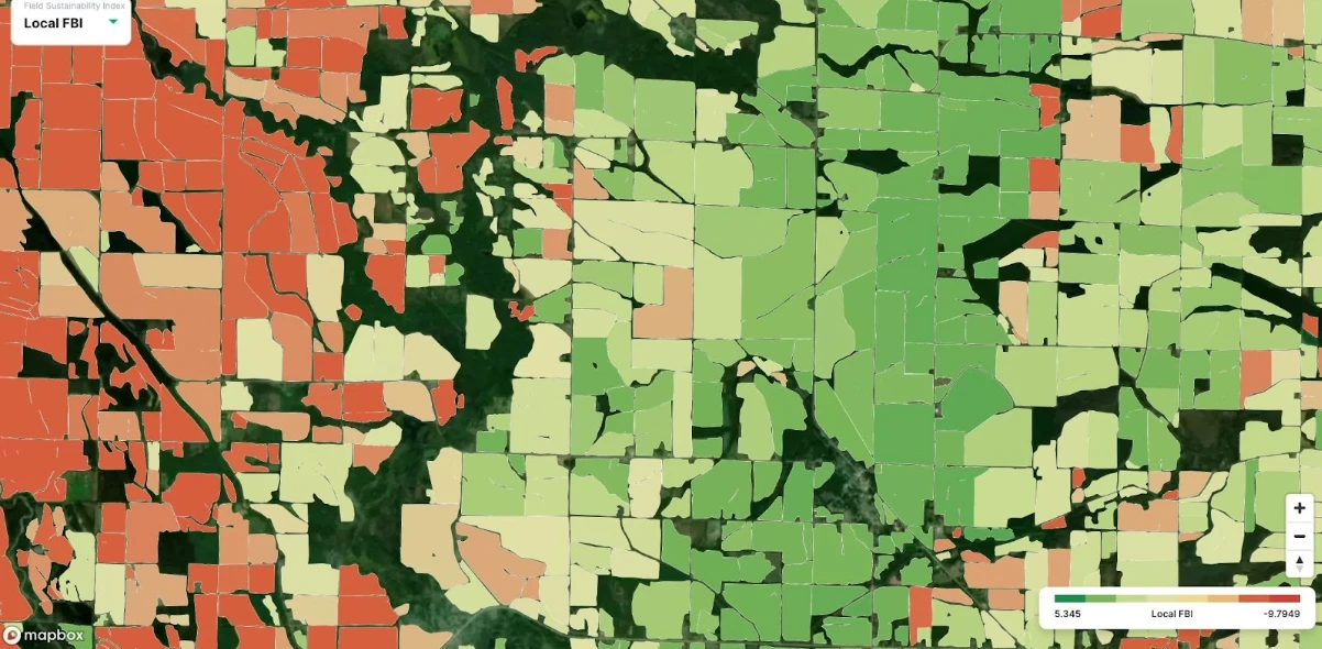
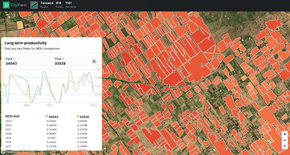
For a long time and especially in traditional forms of financing, one of the key limiting factors for access to loans for smallholder farmers has been lack of collateral. Looking at land ownership registration for instance, data collected by Tanzania’s bureau of statistics in 2018 shows that out of 8.7 million farms surveyed only 18% were registered. To deal with this challenge, alternative financing models based on data, artificial intelligence and machine learning have increasingly been deployed. DigiFarm’s proposed technology therefore seeks to boost confidence in the digital platforms through boosting data accuracy & reliability, doing so on a massive scale and in near real time. The screenshot below highlights the local Sustainability Index, measuring productivity and sustainability historically over a period of 35+ years.
To achieve this, DigiFarm, an ag-tech startup to roll out digital farming solutions to smallholders farmers in Tanzania, based on latest developments in the area of Artificial Intelligence, Machine Learning and Super Resolution Earth-Observation Imagery (Sentinel-1 and 2) in order to deliver near-real time easily digestible, simple and affordable analytics and data on smallholder field-level, which will help farmers optimise crop-input application (seeds/fertiliser/crop protection), monitor water stress and early-detection of disease (pest).
DigiFarm provide this data through employing a deep neural network model based on an algorithm specifically developed to improve resolution of current satellite imagery in automatically detecting field boundaries (and seeded acres), zoning and crop classification with much higher levels of accuracy than currently exists anywhere globally (reaching 10x higher accuracy than current Sentinel-2). Data generated thus will then be made available through powerful API endpoints to end users including smallholder farmers, digital economy platforms and financial technology solutions to drive delivery of bundled services that includes access to high quality agricultural advisory, farm input optimization, markets, insurance, and finance. This includes the ability to assess delineated seeded acres on individual field-level, creating a baseline for financial collateral to banks and lending institutions in addition to crop insurance circumstances, automating processes, workflows, and validation of field-level data.
The technology is built to address current weaknesses in precision farming in smallholder farming contexts including challenges around geo-spatial agricultural analysis. Such include limitations of currently existing spatial resolution imagery data to accurately delineate field boundaries.
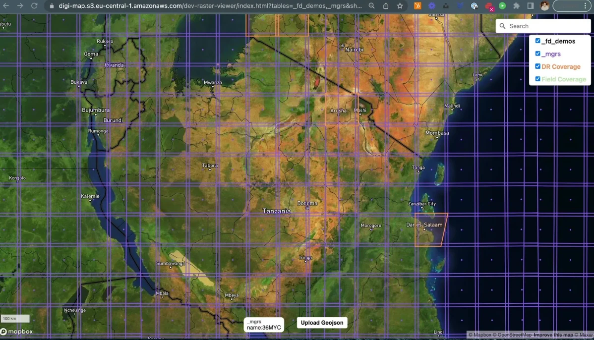
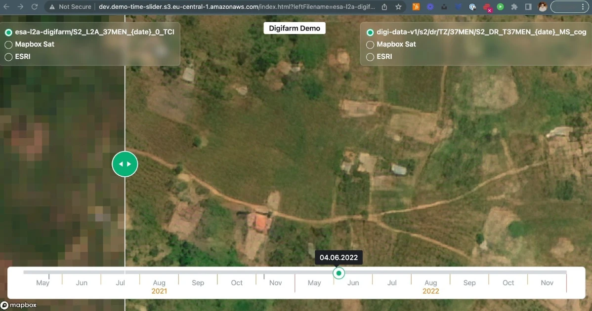
One of the major challenges for being able to delineate agricultural field boundaries in Tanzania is the limitation and cost of acquiring Satellite Earth Observation data, due to the smaller field boundaries, typically a field in Tanzania is less than 0.5 hectares, the challenge becomes publicly and freely available Satellite imagery such as Landsat 7/8 which is 30m per pixel resolution and Sentinel-2 which is 10m per pixel resolution (highest publicly and freely available SatEO data) is insufficient for accurately detecting field boundaries and seeded acres, as can be seen from the screenshot below (example from Tanzania):
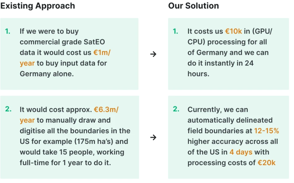
There are alternative imagery sources which could be utilised in order to build models for field boundary and seeded acres detection including: Orthophoto (aerial imagery) or UAV-based (drone) hyperspectral imagery. The challenge with Ortophoto, despite having super-high spatial resolution (~12.5+ cm), is that it’s typically only available once a year or every few years for specific regions, due to the cost of capturing the imagery, it is also not publicly or freely available. This does not provide the frequency of images necessary for delineation of field boundaries multiple times per year, as this requires multi-temporal imagery from the start of growing season (seeding), peak of growing season (biomass peak) to harvesting. Orthophoto imagery is also not publicly and freely available for commercial usage, rendering it too costly (avg. $1-2 per sq.km per image).
The second source of possible imagery is Unmanned Autonomous Vehicles (UAV) and drones which provide hyperspectral imagery and higher resolution than what is available in EO-data. The problem with drones is that it is operationally possible to cover an entire state or country every five-seven days, compared to the temporal resolution of Sentinel. Additionally, if one were to attempt to cover an entire country within a few days it would be operationally and commercially (avg. $8 per sq.km for imagery below 50cm resolution) not feasible to build affordable services on, and in particular for the agricultural industry.
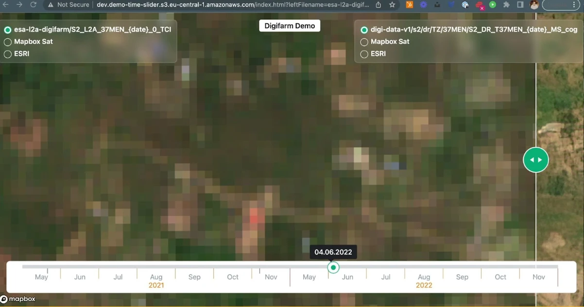
DigiFarm’s key competitive advantage here is the ability to super-resolve Sentinel-2 from 10m to 10m per pixel resolution. This includes Sentinel-2 Surface reflectance in visible and NIR to compute a number of indices like NDVI, EVI, NDWI, TVDI, LAI. DigiFarm uses 4 10m bands of Sentinel-2 in order to deeply resolve the imagery including: 2,3,4 and 8 and also additional 4 20m bands and later 2 more 60m bands, 10 in total. The illustration below highlights the benefits of our solution which makes it economically and operationally feasible to operate within Tanzania and deliver services to smallholder farming markets:
Below is an example from the Tanzania AOI (area of interest) where DigiFarm produced the 1m per pixel imagery from the Sentinel-2 (10m):
In addition, existing large scale field boundaries are managed traditionally through Cadastral map data and national agencies, which gets outdated over time as boundaries and seeded acres change every year, making data unreliable. This is reflected in professional agricultural regions including AR5 (NIBIO) in Norway which dates to the 1990s, LIPS in CAP (EU), CLU’s in the US which are over 12 years old, and is even more present in Tanzania, where there are currently no reliable field boundary identification systems. This poses a significant challenge as the baseline for data collection, thereby reducing the efficacy of the subsequent agricultural analytics.
In line with Cardano’s F8: Nation Building Apps and following challenge KPIs: “What core Nation Building Dapp solutions can be provided for widespread users acquired in the developing world? For the poor nations with no basic foundations, Nation Building Dapp solutions will be the building blocks enabling sustainable prosperity.” Increasing Dapp usage in developing nations, in collaboration with Cardano Local Community Centers and Intl Partnerships to serve its people.
Proposals in Nation Building Dapps will be able to help provide digital identities to these people and help them out of poverty. This is similar to the “Leaving No One Behind” principle in the digital area, hence, this project focused on rural smallholder farmers.
While it is expected that at least 5,000,000 acres will have been covered by the adapted satellite and remote sensing technology by end of Year 1, the number of smallholder farmers benefiting from a digitised and value chain focused utilisation of geo-spatial data through various digital platforms is targeted at 100,000 with a minimum 50% women.
To make this possible local partners, such as UNCDF, will leverage currently supported interventions on digital finance for smallholder farmers. It will avail existing data and insights about Tanzania that will help in driving a better understanding of the local context, facilitate necessary dialogue with the regulators e.g. on allowing third party companies (FinTechs and digital economy platforms) leverage satellite based geo-spatial data in developing and providing various solutions; play the role of a thought leader in facilitating the design and piloting of different use cases, and convene a community of practice around utilization of geo-spatial data across different sectors.
Working to UNCDF’s advantage in implementing such a project is its ability to replicate this model in other developing country contexts regionally, in Africa & globally, strong policy making experience, its expertise building inclusive digital economies ensuring such marginalised segments of the population as women, rural populations, and smallholder farmers are not only part of the process but that they get a seat at the decision-making table. Finally, this fits in well with the decade of action focused around consolidating the gains and accelerating progress towards achievement of the SDGs. This project will specifically contribute to SDGs 1, 2, 5, 9 and 17.

Ready to revolutionize your business and take it to the next level?
Don't miss out on the latest AgTech solutions that can transform your operations and boost your profits. Contact our experts today to learn more about our cutting-edge products and services. Visit our website to explore pricing options and discover how we can help you stay ahead of the competition.


